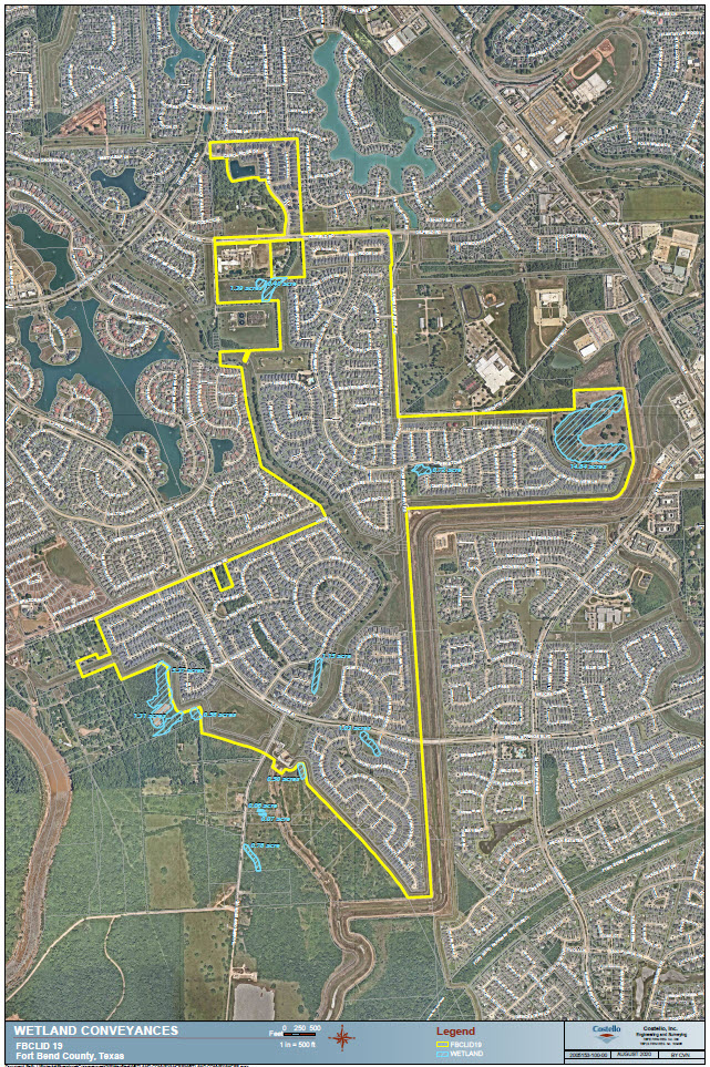
Upcoming Storm Notice 1 (Expect Bad Weather/General Preparation)

With severe weather expected in our area, Fort Bend County Levee Improvement District No. 19 would like to update you regarding the steps we are taking to protect our community. Currently, all pumps are fully functional (including our portable pumps), and we have full retention available if needed.

The storm is expected to make landfall Tuesday evening; as such, please remove all trash receptacles from the street and avoid parking vehicles in the street until after the event has passed. As you know, our roads act as drainage channels during storm events.

Please be aware that the sewer drains may back up, and street ponding / temporary street flooding is possible in times of torrential downpours. While they will ebb as the rain slows, it is critical that you do not drive into high waters.

If there is an emergency and you need immediate assistance, please call 911.

If conditions change, we will provide updates on the district websiteFacebook page, and, if needed, through emergency texts and emails.

For additional information, visit the City of Sugar Land and the Fort Bend County Emergency Management websites.

Tax Collection Changes

The LID 19 board of directors recently approved a change to their tax collection process. They have joined several regional LID’s to have their tax collection services handled by Fort Bend County. This change means that instead of a separate tax bill from the LID, you will receive one common invoice from the county, that will include county, school, and LID taxes all on one document needing just one payment.

While convenience was a minor factor, the main reason for the change was to save your tax dollars. This change will save the district over 97% of what they were paying previously for the LID tax collection process. For LID 19, these savings will be more than $29,000 each year.

The change will go in to effect for the upcoming tax year.

Current Storm Update

Currently, a Tropical Depression is making its way across the gulf. We anticipate landfall sometime after noon on Friday. The cone is veering away from Houston and towards San Antonio.

Regardless of the tracking variances, we will receive large amounts of rain over the weekend. We anticipate that we WILL NOT need to pump water out of the district. The Brazos River water level is anticipated to remain in the low range, so the gravity flow of stormwater is expected to be fully available, thus avoiding the need to pump water from the district. At this point, there is nothing in the forecasts that the systems can not handle. We are fully functional and have reserve pumping capacity if needed (again, we do not anticipate needing that capacity).

It is important to note that despite our ability to handle this amount of rain, a Tropical Depression can bring deluges of rain that will temporarily overwhelm the storm drains. This amount of rainfall may briefly create street ponding or street flooding during times of torrential downpours. When the rain stops or slows, the storm drains will be able to catch up and clear the streets.

Due to this potential, especially during overnight hours, we recommend that you move your cars off the street, particularly if you have a low profile vehicle. Moving them to an elevated location, like your driveway, can save a lot of potential headaches.

Please use caution when driving and do not drive into high waters. We will update this post if the conditions change.